Puerto Prinsesa
Puerto Princesa, officially the City of Puerto Princesa (Cuyonon: Siyudad i'ang Puerto Princesa; Tagalog: Lungsod ng Puerto Princesa; Spanish: Ciudad de Puerto Princesa), and often referred to as Puerto Princesa City, is a 1st class Highly Urbanized City in the Philippines. According to the 2015 census, it has a population of 255,116 people.[5] It is a city located in the western province of Palawan, and is the westernmost city in the Philippines. Though the seat of government and capital for the province, the city itself is one of 38 independent cities within the Philippines not controlled by the province in which it is geographically located and is therefore an independent area located within Palawan. It is the least densely populated city in the Philippines. In terms of land area, the city is the second largest geographically after Davao City with an area of 2,381.02 square kilometres (919.32 sq mi). Puerto Princesa is the location of the Philippines' Western Command headquarters. Today, Puerto Princesa is a tourist city with many beach resorts and seafood restaurants. It has been acclaimed several times as the cleanest and greenest city in the Philippines. Historically, the place was named after Maria Cristina, one of the princesses born to Isabella II of Spain and her consort, Francis, Duke of Cádiz. When the princess suffered an untimely death, the Queen changed the name to Puerto de la Princesa. Eventually, the name was shortened to Puerto Princesa. Spanish Colonizers founded the settlement on 4 March 1872 in the course of their exploration of the province. As they scanned the Palawan shoreline for a capital site, they came upon a hill with steep declivity. Rowing to shore, they surveyed the hill and discovered an extensive plateau which they decided as ideal for settlement. Soon after, Fr. Antonio Muro levelled a portion of the hill to make way for a chapel. (That section is now occupied by the Catholic Cathedral, the P.C. Barracks and the Rizal Park. The Old Municipal Building used to be there, as well as an Elementary School). The first mass celebrated in Puerto Princesa took place at a site where a marker now stands. In May 1872, the Port of Puerto Princesa became the center of Spanish Naval Operations in the area because the Bay met all the Navy’s requirements. Royal Decrees later provided incentives to settlers, and by 1883 the settlement had flourished into a town of twelve roads, a hospital and well-built port. In 1894, Puerto Princesa was recognized by government authorities as one of the most beautiful towns in the country by virtue of the orderly distribution of streets, buildings and houses as well as the cleanliness of the community
El Nido
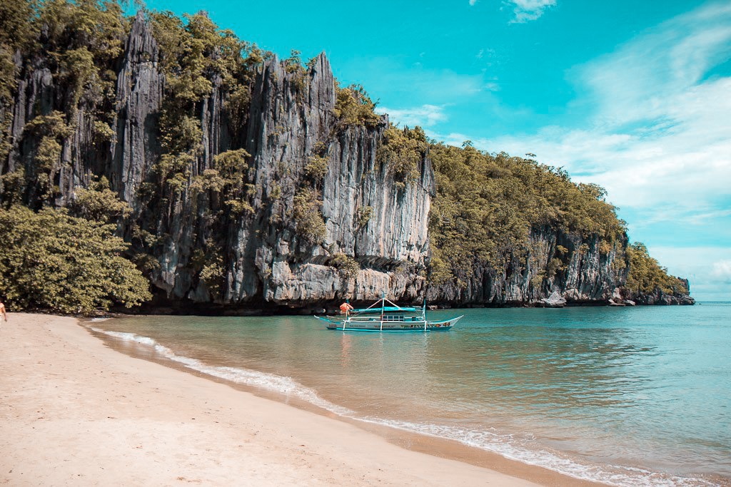
El Nido, officially the Municipality of El Nido, (Tagalog: Bayan ng El Nido), is a 1st class municipality in the province of Palawan, Philippines. According to the 2015 census, it has a population of 41,606 people. It is about 420 kilometres (260 mi) south-west of Manila, and about 238 kilometres (148 mi) north-east of Puerto Princesa, Palawan’s capital. A managed resource protected area, it is known for its white-sand beaches, coral reefs, limestone cliffs and as the gateway to the Bacuit archipelago. El Nido is currently ranked #4 in Condé Nast Traveler's list of "20 Most Beautiful Beaches in the World." CNNGo has called it the Best Beach and Island destination in the Philippines for its "extraordinary natural splendor and ecosystem." El Nido has been inhabited by humans as early 2680 BC, or even up to 22,000 years ago. This was confirmed by the fossils and burial sites, dating back to the Late Neolithic Age, that can be found in many caves and excavation sites surrounding the municipality, particularly in Dewil Valley's Ille Cave in New Ibajay. Chinese traders had been regularly visiting the area of Palawan for its edible birds' nests during the Song Dynasty (960-1279). The island was mentioned in Chinese records of 1225. Chau Ju-Kua, a trade commissioner of the port of Chuan wrote about the island, Pa-Lao-Yu or Land of Beautiful Harbors in his book Chu Fan Chi. The town traces its roots from a small Tagbanwa village called Talindak. Some time in the 16th century, waves of migrants from Cuyo Islands came here to settle. In the 1800s, the Spaniards arrived, and they moved to the part where the present-day Población and Mabini are located. The first Spanish families were the Canovas, Vázquez, Ríos and Rey. In 1890, the Spaniards renamed it as Bacuit. At the time, the center of the town was Cabigsing, then known as Inventario. Chinese families moved into the area about the same period, first settling in Langeblangeban. The first Chinese settlers were named Lim, Chin, Liao, Edsan, Ambao, Que-Ke, Lim Piao, Yu His, Pe Phan and Pe Khen. During the Spanish colonization of the Philippines, the town was under the jurisdiction of the Municipality of Taytay, which was the capital of the former Province of Calamianes from 1818, and the Province of Castilla, the area of what is now known as northern Palawan, from 1858. It remained part of Taytay until 1916 when it formally became an independent municipality. The new municipality was then known as Bacuit. On June 17, 1954, Republic Act No. 1140 was approved changing the name of the town from Bacuit to its present name El Nido after the edible nests of swiftlets (collocalia fuciphaga), found in the crevices of its limestone cliffs. These nests, nido in Spanish, the main ingredient for the gourmet nido soup, are being sold at approximately US$ 3,000 per kilogram. In 1957, the following barrios were created: Villa Paz comprising the sitios of New Igabas, Candolay, Malapaho, Mabeñgeten, Dewel, Nalbekan, and Lapia; Bebeladan comprising the sitios of Mainlong, Bolabod, Balete, Culiong, Codongnon, Vigan, Pagawanen, Langeblangeban, Talulap, Bocboc, Miadiao, Avirawan, Pita, Deboluan, Balay-Bacaco, Kiminawit, Pamontonan, Simpian, Binabanan, Tegas, and Pinacpanacan; Bagong-Bayan comprising the sitios of Manogtog, Cadleman, Pinagtual, Omao, Nami, Tebey, Bato, Tuñgay, Cataaban, and Lomocob; Pasadeña comprising the sitios of Lamoro, Cagbatang, Bulalacao, Pinañganteñgan, Quinawañgan, Nagbaclao, Colantod, Loblob, and Badiang; Sibaltan comprising the sitios of Turatod, Buluang, Santa Monica, Senodioc, Laolao, Caboñgan, Tapic, Panian, Guitan, Loro, and Nagcalasag; Barotuan comprising the sitios of Taberna, Locaroc, Nagpan, Yocoton, Calitang, Wawa, Makinit, Canoling, Mabañgaon, and Mapeldeten; San Fernando comprising the sitios of Panian, Madorianen, Dipnay, Maubog, Guenleng, Palabuayan, Parañgaycayan, San Pablo, and Olac-olacan; and, Villa Libertad comprising the sitios of Calelenday, Taolili, Boloc, Inigtan, Mepague, Matolatolaon, Dao, Batbat, Madacotdacot, Nasigdan, Semenled, Bancalen, and Cagbanaba.[18] In the same year, the barrio of Oton was renamed to Mabini. Because El Nido was quite remote from most of the inhabited islands in the Philippines, its pristine beauty was hidden to the world until 1979 when a sea accident happened in Bacuit Bay. As the story goes, "a tuna line disabled a dive boat's propeller in the middle of the night forcing it to drop anchor in an inlet. The following morning, the divers woke up to an amazing scenery of skyscraping dark cliffs, thick green forest, white sandbeach, sparkling water and, rising above it, a series of magnificently sculpted jade islands." In 1983, a dive station was established in Miniloc Island by a group of divers who were on board the dive boat M/V Via Mare. In the same year, major tourism commenced in El Nido, when the Ten Knots Development Corporation, a Filipino-Japanese joint venture company, opened a divers' resort on Miniloc Island, and an airstrip (Lio Airport) at Villa Libertad on the mainland. In 1992, the company set up a second resort on Pangulasian Island, and in 1998, the third and largest Ten Knots resort on Lagen Island. The opening of the third resort coincided with the destruction of the Pangulasian Resort by fire. During this period several other tourism establishments were developed, paving the way for tourism to become a thriving economic sector. El Nido is a showcase of the Philippines' geological and biological diversity. In recognition of the"" importance of its unique ecosystem, the Philippine government made the entire area of El Nido first to a turtle sanctuary in 1984, then to a marine reserve park in 1991,[20] and finally in 1998, to that of a managed resource protected area. In April 2019, a bill dividing Palawan into three provinces was passed into law after the bill was signed by President Rodrigo Duterte. The three new provinces are Palawan del Norte, Palawan Oriental, and Palawan del Sur. A plebiscite will be held on May 2020 to decide on whether Palawan will be divided into three provinces or not. Some civil society groups opposed the proposed division, claiming that there was no extensive public consultation, which was later proven as consultations and a study were only made in a single town, El Nido. Additionally, reports have confirmed that China's Shanghai Electric Corporation has been tapped by the government to overtake Palawan's electric industry once the province has been divided in 2020. The proposed electric base of the Chinese corporation will be at El Nido town, near the West Philippine Sea, which China has claimed as its 'integral territory'
Coron
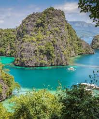
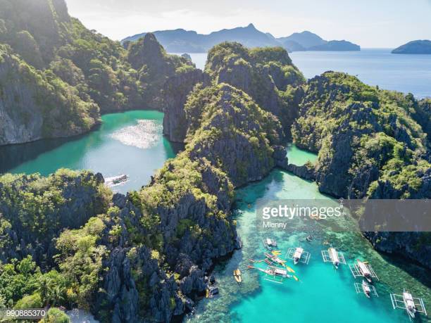
Coron is the third-largest island in the Calamian Islands in northern Palawan in the Philippines. The island is part of the larger municipality of the same name. It is about 170 nautical miles (310 km) southwest of Manila and is known for several Japanese shipwrecks of World War II vintage. Because of its unique ecological features, the entire area is protected by several legal proclamations. The island and surrounding fishing grounds are part of the ancestral domain of the indigenous Tagbanwa people, officially designated such on June 5, 1998. Known as Calis among the Tagbanwas and Coronians, its tribal chieftain is Rodolfo Aguilar I. The island comprises two barangays of the municipality of Coron: Banuang Daan and Cabugao. Partially between Busuanga and Culion islands, Coron Island faces the Sulu Sea and forms the eastern side of Coron Bay. It is about 20 kilometres (12 mi) long from north to south, and 9 kilometres (5.6 mi) at its widest point. It is a wedge-shaped mountainous island, dominated by steep cliffs and Karst rock formations made of Permian limestone of Jurassic origin that comprises about 70% of its area. Another 25% is rolling hills, while only 5% is relatively flat. There are 11 lakes nestled in the rugged terrain, of which 3 have underground connections to the sea. There are a few mangroves in coastal areas. next